NOAA Tide Chart & Forecast
- 3.8
- Rating
- 10.00K
- Installs
- Free
- Price
 Analysis by App-foxy
Planning around the coast is often less about knowing whether the sky is clear and more about knowing what the water will do. A beach walk, kayak launch, fishing trip, harbor visit, or photography session can all change dramatically with the tide. NOAA Tide Chart & Forecast is a weather app from NextStack LLC that focuses on that specific problem rather than trying to become a complete daily forecast service.
I found its appeal in the narrow focus. Instead of making me search through a general weather app for tide information, it puts tide charts, forecasts, predictions, and longer-range tracking at the center. The app is free to install, carries an Everyone content rating, and is available for devices running Android 8.0 or later. There are also in-app purchases ranging from $2.99 to $24.99 per item, so the free starting point is useful, but anyone expecting every part of the experience to remain free should check the available options before relying on it regularly.
From a vague coastal plan to a usable tide decision
When I move from “maybe we’ll go to the coast” to choosing a workable time, the key is to connect the tide chart to the actual place and the people involved. I’d settle on a relevant station first, then turn the useful window into a clear arrival and return plan rather than forwarding a chart without context. That practical handoff matters even more when the next decision is how the app fits into a shared household routine.
You May Also Like

 AccuWeather: Weather Radar
AccuWeather Review: A Quick, Clear Forecast for Everyday Decisions
For everyday plans, the best forecast is the one you can understand quickly. AccuWeather makes rain timing, radar, and local conditions easy to act on, with a few trade-offs.

 Hill Climb Racing
Why Hill Climb Racing Still Turns Crashes Into One More Run
A tiny car, a bumpy hill and one more upgrade: Hill Climb Racing keeps resurfacing because its simple chaos makes every near-miss feel personal.

 AliExpress - Shopping App
AliExpress Makes Global Shopping Feel Personal, but Shoppers Bear the Risk
AliExpress turns a global marketplace into a pocket-sized discovery engine. Its reach is useful, its shopping loop compelling, and its trade-offs easy to miss.

 Lords Mobile: Kingdom Wars
Lords Mobile Is a Kingdom-Building Routine, Not a Quick Match
A case-by-case verdict on the building, battles, device demands, and social commitments that make Lords Mobile rewarding for some players and exhausting for others.

 PDF Scanner app - TapScanner
TapScanner Makes Paperwork Easier to Capture, Check, and Share
TapScanner makes scanning with a phone feel less like a rescue operation and more like a dependable step in getting work done. Its capture tools are useful, though not flawless.

 Block Blast!
 Shows How Much a Puzzle Game Can Leave Out
A quiet grid game shows why puzzle players increasingly value instant clarity, repeatable skill and low-pressure play—and where the genre still needs to catch up.
More From Our News Desk
View All News


Starting with the actual question
My first useful question was not “What is the weather?” but “Will the water be where I need it to be when I arrive?” That distinction matters. A standard weather app may show wind, rain, temperature, and perhaps a basic marine forecast, but those details do not replace a tide table. NOAA Tide Chart & Forecast is better suited to the moment when the tide itself is the deciding factor.
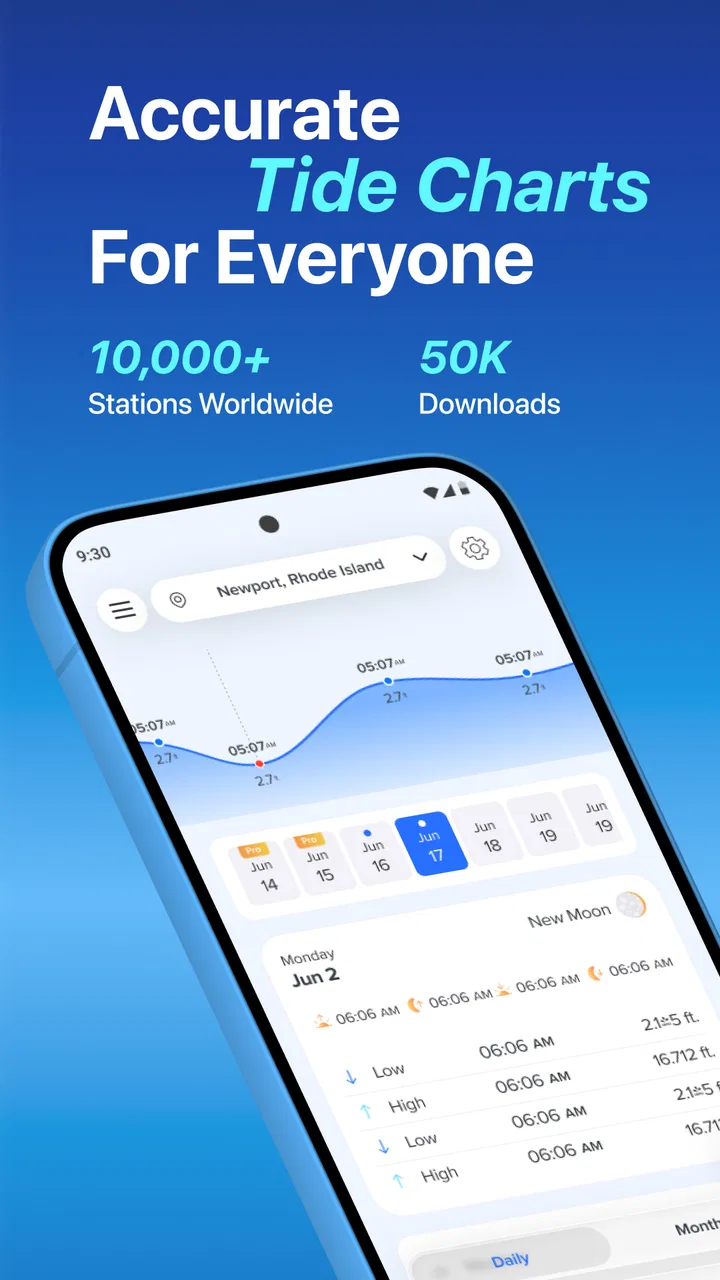
The app’s store summary points to real-time tides, longer-range tracking, and tide forecasts and predictions. In practice, that makes it most interesting for people who repeatedly visit the same shoreline or who need to compare several possible days before committing to a plan. It is not just a glance at the current conditions; it is a tool for turning a coastal schedule into something more deliberate.
That narrow purpose is also its first limitation. If I want a broad forecast covering severe weather, road conditions, radar, air quality, and hourly temperature changes, I would still open a conventional weather app. This one should be treated as a tide-focused companion, not a replacement for every weather source on a phone.
Choosing the location before trusting the result
The quality of any tide decision depends on the location selected. A nearby beach, marina, inlet, and open shoreline can experience noticeably different timing and water levels. My practical advice is to select the station that best represents the place where you will actually launch, fish, walk, or photograph, rather than simply choosing the closest town name.
This is one of the most important handoffs in the whole workflow: the app can present a chart, but I still have to make sure the chart belongs to the right coastal point. A technically clear prediction for the wrong station can create more confidence than a plainly displayed prediction used correctly. Before planning around a narrow window, I would compare the selected location with the real access point and keep the station choice consistent from one trip to the next.
For a casual beach visit, a nearby station may be adequate. For kayaking through a shallow channel or timing a fishing session around moving water, the station choice deserves more attention. The app is useful here because its focused design encourages me to think in terms of tide locations rather than treating the entire coastline as one uniform place.
Reading the chart as a schedule, not a decoration
The central value of a tide chart is that it helps me see change across the day. I am not only looking for whether the tide is high or low. I am looking for the relationship between the predicted turning points and my own schedule: arrival, setup, launch, activity, return, and any handoff to another person.
For example, imagine I am meeting a friend at a small launch area after work. I can use the chart to check whether the water should be suitable when we arrive, whether the return window will occur before conditions become awkward, and whether a delayed start would move us into a less convenient part of the cycle. That is more useful than checking the tide once and then forgetting it. The chart becomes a planning timeline.
A non-obvious benefit is that the app can help separate “possible” from “comfortable.” A tide may technically allow a plan, but the available window may be too tight once parking, carrying equipment, launching, and returning are included. I would build those transitions into the decision rather than treating the predicted tide event as the entire outing.
Using longer-range tracking without overcommitting
The longer-range tracking is helpful when I am comparing dates instead of making a same-day decision. A 90-day view can support planning for a holiday, a recurring fishing routine, a photography project, or a series of weekend outings. I can look for days whose tide timing fits the activity, then check the broader weather forecast closer to the date.
That separation of jobs is important. I would use the tide information to shortlist dates, not to guarantee that a trip will be good weeks in advance. Wind, rain, swell, visibility, and local access can still change the outcome. The longer view answers “When might the water work for us?” while a general weather source answers “Is the day itself practical and safe?”
A useful workflow is to make a small shortlist rather than choosing one perfect date immediately. I can identify several promising tide windows, then revisit them as the outing approaches. This reduces the risk of building an entire plan around one prediction that later clashes with weather or personal availability.
Handling the handoff from app to real-world plan
The app does not make the final decision for me, and that is where disciplined use matters. Once I have found a suitable tide window, I need to pass it into a calendar, message, notebook, or shared plan. I would record the location, the intended arrival time, the activity, and the latest acceptable return time. Without that handoff, a useful chart can remain isolated on my phone while everyone else works from a vague “around low tide” assumption.
For a group outing, I would send the practical conclusion rather than a screenshot alone: where we are meeting, when we should arrive, and how much flexibility we have. A screenshot can show information, but it does not explain which part matters. This is especially useful when one person is driving, another is carrying equipment, and someone else is responsible for checking the weather.
For solo use, the handoff is simpler but still valuable. I can save the planned time in my calendar and set a reminder to recheck conditions before leaving. The tide chart supports the plan; it should not become the only check performed before heading out.
What the result looks like in everyday use
The best result is not a dramatic prediction. It is fewer avoidable surprises. I can arrive when the shoreline, channel, or launch area is closer to the condition I expected. I can avoid scheduling a short activity during an inconvenient part of the tide cycle, and I can explain the plan to someone else without relying on guesswork.
For a photographer, the result may be a better chance of reaching a particular stretch of exposed shoreline at the intended time. For a shore angler, it may help organize the session around a chosen part of the cycle. For a family visiting the coast, it can prevent a child-friendly beach plan from being built around water conditions that make the intended area less accessible.
These are modest improvements, but they are exactly where a focused tide app earns its place. I do not need it to entertain me or manage unrelated forecasts. I need it to answer a coastal timing question clearly enough that I can combine the answer with local knowledge and current conditions.
Where the flow breaks
The workflow breaks first when I confuse prediction with certainty. Tide information is valuable, but it does not tell me everything about waves, currents, storm surge, shoreline access, or hazards at a particular site. A chart can support planning without making an exposed activity safe. For boating, paddling, or fishing in changing conditions, I would still consult appropriate local guidance and current weather information.
It can also break when the selected station is treated as a perfect match for a complicated coastline. Estuaries, narrow inlets, channels, and sheltered harbors may not behave exactly like a more open reference point. If the activity depends on a very specific water level or current, I would use the app as one input and verify the local context through experienced advice or another reliable source.
Another friction point is the business model. The app is free, but in-app purchases are present, with individual items priced from $2.99 to $24.99. That does not automatically make it poor value, yet it means I would explore the free experience first and decide whether the extra functions justify the cost for my routine. Someone who only checks tides a few times each summer may prefer a simpler free alternative, while a regular coastal user may get more value from a dedicated tool.
The app’s public reception is mixed rather than overwhelming. It has an average rating of 3.8 from around 89 ratings, with around 47 written reviews, and its install count is over 10 thousand. I read that as a sign to keep expectations practical: it has a clear audience and a focused purpose, but it is not a universally loved weather solution. The current version is 2.7.6.63, which is useful to know when checking compatibility or comparing the experience on a device.
Who should use it, and who should choose something else?
I would recommend NOAA Tide Chart & Forecast to someone who regularly plans around coastal water levels and wants a dedicated place to examine tide timing. It is particularly suitable for people who compare dates, revisit familiar shoreline locations, or need to coordinate an activity with another person. The longer-range view gives it more planning value than a basic “current tide” display.
I would be less likely to recommend it as the only weather app on a phone. If your main concern is rain arriving during a commute, temperature changes, lightning, radar, or a broad daily forecast, a full weather service will be more appropriate. Likewise, a professional or safety-critical marine user should not treat a general tide app as a substitute for specialized navigation information, local notices, or official warnings.
It may also be unnecessary for someone who rarely visits the coast and only wants a quick answer for one beach trip. In that situation, a local tide table or a general weather app with tide support may be simpler. The dedicated focus becomes worthwhile when tide planning is a repeated need rather than an occasional curiosity.
My practical setup for getting more from it
I would begin by identifying the locations I actually use, then checking several dates instead of stopping at the first acceptable result. I would note the time needed for travel and setup, not just the activity itself. If the plan involves a handoff between people, I would share the agreed arrival and departure times in plain language.
I would also use the 90-day tracking as a planning aid, not as a promise. Once a date is selected, I would return closer to the outing and combine the tide information with a current weather check. For a sensitive plan, I would keep a backup date in mind. This approach turns the app from a passive chart into part of a repeatable process.
Finally, I would avoid making decisions from a single number or a single glance. The useful insight is the shape of the day and how it fits the real schedule. A tide window that looks ideal on the screen may be poor once driving, equipment, daylight, weather, and the return journey are included.
Final assessment
NOAA Tide Chart & Forecast succeeds because it concentrates on a real planning problem: matching coastal activities to changing water conditions. I like it more as a practical tide companion than as a complete weather application. Its real-time information, forecasts, predictions, and extended tracking can help me move from a vague idea to a timetable that other people can follow.
The trade-off is that the app still requires judgment. I must choose the right station, allow time around the predicted event, check current weather separately, and understand that local conditions can complicate a chart. The presence of paid items also means I would test the free portion before deciding whether it fits my budget.
My recommendation is straightforward: coastal visitors who plan around tides should give it a try, especially if they need to compare dates or repeat the same type of outing. People seeking an all-purpose weather dashboard, advanced marine navigation, or a one-off answer may be better served elsewhere. Used within its proper limits, this focused weather app can make tide-based planning clearer and reduce the guesswork that often causes coastal plans to go wrong.
FAQs for NOAA Tide Chart & Forecast
01What is NOAA Tide Chart & Forecast used for?
NOAA Tide Chart & Forecast is designed to help users check predicted tide levels and times for coastal locations in the United States. It can be useful for planning fishing trips, boating, kayaking, beach visits, surfing, photography, and other activities affected by changing water levels. The app presents tidal information in a more convenient format than searching through NOAA pages manually, although it should be treated as a planning aid rather than a replacement for official safety information.
02How accurate are the tide predictions in the app?
The app generally relies on official NOAA tide predictions, which are calculated from established tidal stations and are highly useful for normal planning. However, predicted tides are not the same as real-time water conditions. Wind, storms, atmospheric pressure, rainfall, waves, and local geography can change actual water levels. Before going on the water, users should compare the app with current NOAA updates, weather forecasts, marine warnings, and local conditions.
03Can I use NOAA Tide Chart & Forecast without an internet connection?
Some previously viewed information may remain available depending on the app version, device settings, and how the application stores station data. Nevertheless, users should not assume that every feature works offline. Searching for new locations, refreshing forecasts, viewing updated weather details, or accessing map-based information may require an internet connection. It is a good idea to open the desired station before traveling and save or note important tide times in advance.
04Does the app provide tide information for every coastal location?
The application is primarily based on available NOAA tide stations, so coverage is strongest around locations monitored by NOAA and other supported data sources. It may not provide a dedicated station for every beach, marina, island, or remote shoreline. When a precise location is unavailable, the app may show information from the nearest station, but that prediction might not perfectly represent local conditions. Always check the station name and distance before relying on the results.
05Is NOAA Tide Chart & Forecast free to download and safe to use?
The app may be available as a free download, although certain versions can include advertising, optional purchases, or premium features. Users should review the current store listing for exact pricing, subscriptions, permissions, and supported devices before installing. As with any navigation or weather-related app, download it from the official Google Play Store or Apple App Store. Also remember that tide predictions are informational and should not replace official emergency alerts or professional marine guidance.
Pros
- Accurate tide predictions sourced from NOAA stations.
- Includes sunrise
- sunset
- moonrise
- and moonset information.
- Useful charts make tidal changes easy to understand.
- Supports planning for fishing
- boating
- surfing
- and beach trips.
- Provides location-based forecasts for many coastal areas.
Cons
- Coverage may be limited outside U.S. coastal waters.
- Some features may require an internet connection.
- Forecast accuracy can vary during unusual weather conditions.
- The interface may feel dated compared with newer weather apps.
- Station selection can be confusing for first-time users.

NOAA Tide Chart & Forecast
Gallery